


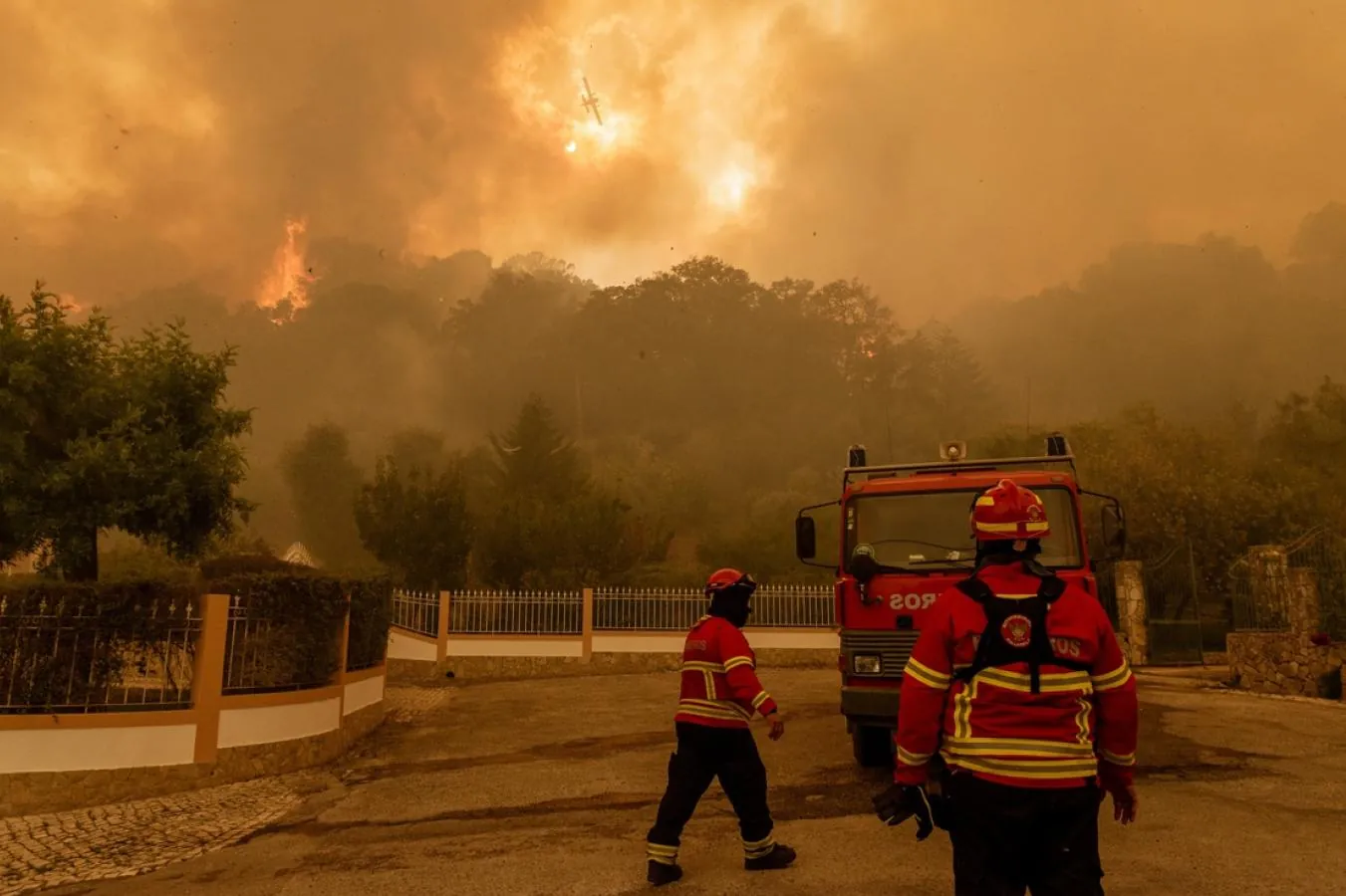
An Overview of Portugal's Forests and the Evolution of Wildfires
Portuguese territory is characterised by a strong presence of forested areas, covering 36% of the total surface, which corresponds to 3.3 million hectares. Forests, together with scrubland and unproductive areas, make up around 70% of land use. This forest predominance plays a fundamental role in conserving biodiversity, capturing carbon and maintaining ecosystem services.
Distribution of forest formations
- Eucalyptus: accounts for 26% of the forest area and is widely used in the pulp industry, though it raises concerns regarding ecological sustainability and water resource management.
- Maritime pine: occupies 22% of forest land and is one of the most significant native species, with a considerable impact on the national forestry economy.
- Cork oak and holm oak: the oak species (cork oaks, holm oaks and others), which together account for 36% of the mainland's forest area, are of great ecological and economic importance, above all the cork oak on account of cork production.
- In the Azores, endemic species predominate, such as incenso (24 kha) and cedro (22 kha), while in Madeira the laurissilva forest stands out, a natural heritage of high ecological value covering 15 kha.
Over the course of the twentieth century there was a significant expansion of forested areas, particularly with the growth of pine woods (maritime pine) up to their peak in 1980. From the 1990s onwards, however, this trend reversed, accompanied by a stabilisation of the forested surface and an increase in scrubland and spontaneous pasture. It is worth noting that the rapid expansion of eucalyptus, which began in the 1960s, has established itself as one of the most significant changes in land use, with implications for fire management and biodiversity.
Forest management in Portugal
Forest management in Portugal is largely dominated by private owners, who control 91% of forested areas. Only 3% of forests are in public hands (the State and local authorities), while 6% are managed by local communities under the baldios system, common land that plays a vital role in the preservation and sustainable use of natural resources.
Around 46% of forested areas remain unregistered in the land registry, creating challenges for efficient management and spatial planning. The shortcomings of the cadastral system make it harder to apply management plans and fire prevention measures, and to implement long-term forestry policy.
The ICNF (Institute for Nature Conservation and Forests) is responsible for managing more than 65 thousand hectares of public land, as well as overseeing some 300 thousand hectares of baldios under the forestry regime. A simplified cadastral information system is being rolled out, with the aim of closing the gaps in the registry and optimising the sustainable management of the territory.
Main challenges and opportunities
Sustainability of eucalyptus plantations:
Although it is an important economic resource, there is a need to promote sustainable forest management practices, with an emphasis on ecological diversity and on resilience to climate change and fire.
Fragmentation of ownership:
The high proportion of private property and the unregistered land holdings prevent the implementation of integrated management and conservation policies.
The baldios system:
This system of community management is an opportunity to involve local communities in the sustainable management of forest resources, promoting agroforestry and conservation practices.
Forest area burned over the last 6 years
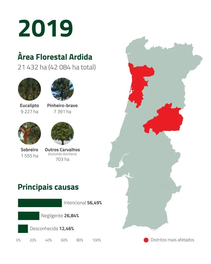
2019
Forest area burned: 21,432 ha.
Main species burned: Eucalyptus (9,227 ha); Maritime pine (7,391 ha); Cork oak (1,555 ha); Oak (703 ha); Holm oak (666 ha).
Worst affected districts: Castelo Branco (8,512 ha); Aveiro (2,733 ha); Porto (1,242 ha).
Main causes: Deliberate – 56.49% (12,106 ha); Negligence – 26.84% (5,752 ha); Unknown – 12.46% (2,670 ha).
With a total of 21,432 hectares burned, this year stood out for the combination of species affected, with eucalyptus and maritime pine predominating. In 2019, the Portuguese forest was made up mainly of Eucalyptus (26%), Maritime pine (22%) and Cork oak (23%).
2020
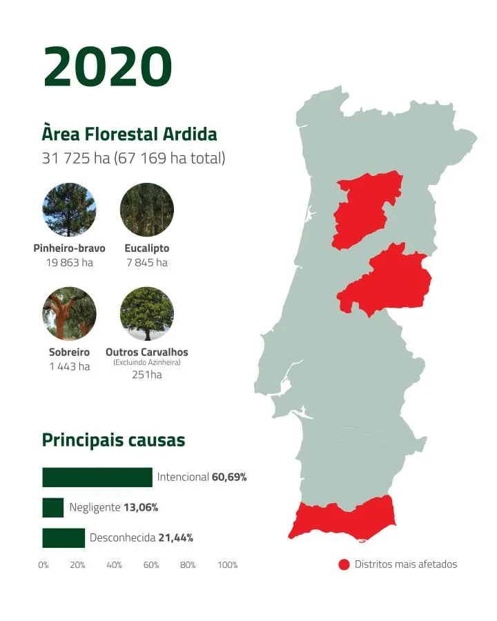
Forest area burned: 31,725 hectares.
Main species burned: Maritime pine (19,863 ha); Eucalyptus (7,845 ha); Cork oak (1,443 ha); Oak (251 ha); Holm oak (31 ha).
Worst affected districts: Castelo Branco (18,496 ha); Viseu (2,543 ha); Faro (2,052 ha).
Main causes: Deliberate – 60.69% (19,252 ha); Unknown – 21.44% (6,800 ha); Negligence – 13.06% (4,143 ha).
2021
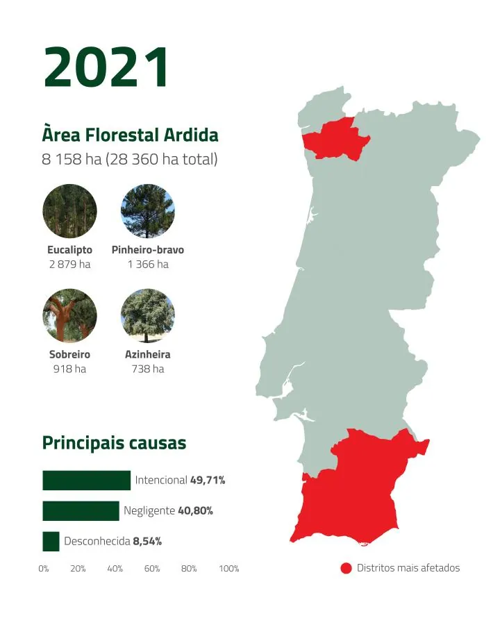
Forest area burned: 8,158 ha.
Main species burned: Eucalyptus (2,879 ha); Maritime pine (1,366 ha); Cork oak (812 ha); Holm oak (738 ha); Oak (185 ha).
Worst affected districts: Faro (3,207 ha); Beja (1,111 ha); Braga (679 ha).
<p”>Main causes: Deliberate – 49.71% (4,055 ha); Negligence – 40.80% (3,329 ha); Unknown – 8.54% (697 ha).
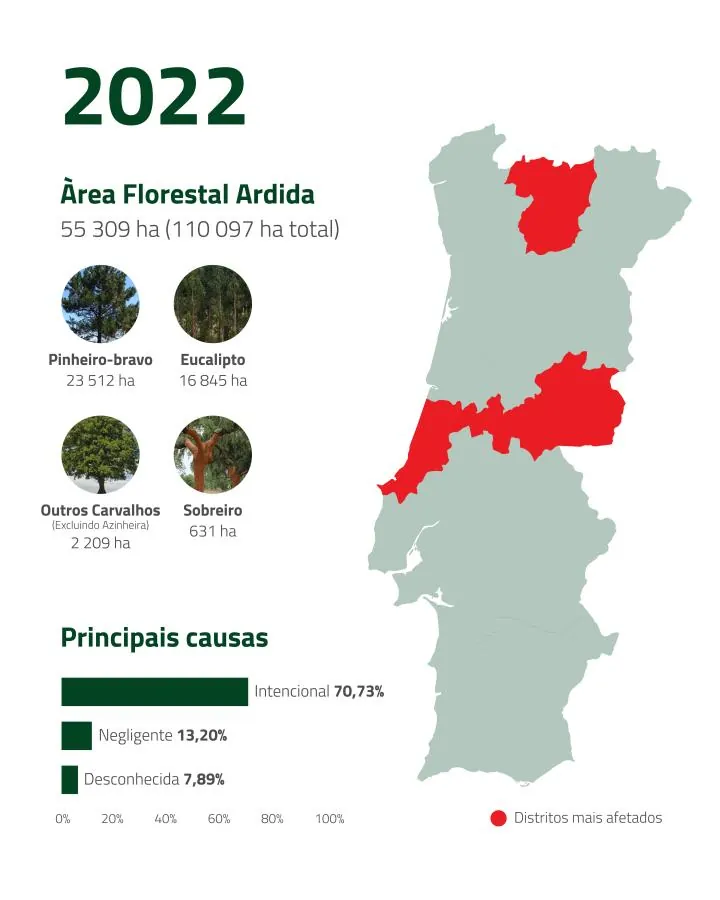
2022
Forest area burned: 55,309 ha.
Main species burned: Maritime pine (23,512 ha); Eucalyptus (16,845 ha); Oak (2,209 ha); Cork oak (631 ha); Holm oak (197 ha).
Worst affected districts: Castelo Branco (14,220 ha); Vila Real (10,709 ha); Leiria (6,346 ha).
Main causes: Deliberate – 70.73% (39,120 ha); Negligence – 13.20% (7,303 ha); Unknown – 7.89% (4,364 ha).
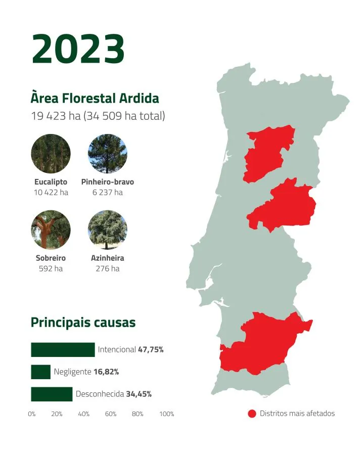
2023
Forest area burned: 19,423 ha.
Main species burned: Eucalyptus (10,422 ha); Maritime pine (6,237 ha); Cork oak (592 ha); Holm oak (276 ha); Oak (237 ha).
Worst affected districts: Beja (5,559 ha); Castelo Branco (5,324 ha); Viseu (1,254 ha).
Main causes: Deliberate – 47.75% (9,275 ha); Unknown cause – 34.45% (6,692 ha); Negligence – 16.82% (3,268 ha).
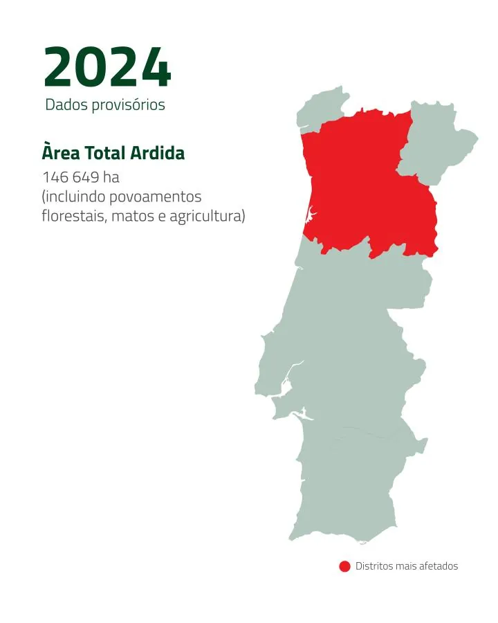
2024 (up to 31 August)
Total area burned: 144,649 ha (as at the date consulted – 20/09/2024).
In 2024, up to 31 August, the total area of rural fires stood at 4,457 ha (of which 3,655 ha related to forest stands). Up to the end of August, as the ICNF indicated, this was set to be the year with the fewest fires since 2014. Recent events, however, have made it the third worst year of the decade and the worst since 2017, the year of the Pedrógão Grande tragedy.
To date, 2024 records 146,649 ha of burned area (including forest stands, scrubland and farmland) (Source: European Forest Fire Information System).
The worst affected areas were Alto Tâmega, Ave, Região de Aveiro, Tâmega e Sousa and Viseu Dão Lafões.
Sources: ICNF – Instituto da Conservação da Natureza e das Florestas, I.P. European Forest Fire Information System.
What do you make of these figures?
Tell us in the comments!
Keep exploring
The Galega, the Cobrançosa and the Verdeal: The Portuguese Native Varieties Conquering the World
At a time when olive oil is establishing itself as one of the most studied and most highly valued foods of the Mediterranean diet, Portugal is emerging as one of the leading players in the global market.
Climate change in Portuguese vineyards: what is changing and how to adapt?
In 2024, the International Organisation of Vine and Wine (OIV) recorded the lowest level of world production since 1961.

Frequently Asked Questions: Artificial Intelligence in Tourism Course
What is the aim of the AgroB Business School course on Artificial Intelligence in Tourism?